- Home
- Albums
- Western Europe
- England, Sept. 5-7, 2016
- England/Belgium/Wales, July 5-16, 2005
- France, May 12-29, 2018
- Days 1-3, Paris, Mont Saint-Michel
- Day 4, Notre Dame; Marais
- Day 5, Normandy
- Day 6, Rodin Museum; Seine Cruise
- Day 7, Paris: City Tour, Musee d’Orsay & l’Orangerie, Montmartre
- Day 8, Champagne; Dijon
- Day 9, Burgundy, Beaune, Lyon
- Day 10, French Alps, Sisteron, Grasse, Cannes
- Day 11, French Riviera
- Day 12, Avignon, Pont du Gard
- Day 13, Carcassonne; Lourdes
- Day 14, Lourdes, Bordeaux Wine Country, Saint-Emilion
- Day 15, Bordeaux
- Days 16-18, Loire Valley, Cognac, Paris
- France/England/Belgium, Sept. 9-26, 2004(A)
- France/England/Belgium, Sept. 9-26, 2004(B)
- Greece/Turkey, Oct. 12-Nov. 5, 2005(A)
- Greece/Turkey, Oct. 12-Nov. 5, 2005(B)
- Greece/Turkey, Oct. 12-Nov. 5, 2005(C)
- Ireland, Sept. 12-28, 2016
- Italy, April 17-May 8, 2005(A)
- Italy, April 17-May 8, 2005(B)
- Italy, April 17-May 8, 2005(C)
- Italy/Switzerland, Sept. 27-Oct. 8, 2007
- Northern Ireland, Sept. 8-12, 2016
- Northern Ireland/Ireland, Sept 8-12, 2016
- Portugal, March 19-April 5, 2008(A)
- Portugal, March 19-April 5, 2008(B)
- Portugal/Spain/France/Andorra, May 29-June 19, 2019
- Days 1-3, Lisbon
- Day 4, Lisbon
- Day 5, Lisbon, Casais, Cabo da Roca, Sintra
- Day 6, Fatima, Porto
- Day 7: Porto, Portugal, to Santiago de Compostela, Spain
- Day 8, Santiago de Compostela & La Coruna
- Day 9, Luarca, Espana Verde, Oviedo
- Day 10, Santander; Bilbao
- Day 11, San Sebastian; French Basque Country
- Day 12, Pamplona; Zaragoza
- Days 13-15, Barcelona
- Day 16, Barcelona
- Day 17, Girona; Figueres: Salvador Dali Museum
- Days 18-19, Barcelona
- Day 20, Three-Country Tour; Monserrat
- Day 21, Barcelona, Going Home
- Scotland, July 18-23, 2005
- Spain, Oct. 13-18, 2006(A)
- Spain, Oct. 13-18, 2006(B)
- Spain, Oct. 24-25, 2010
- Canada
- British Columbia, Feb. 24-28, 2005
- Maritimes, Oct. 5-15, 2015, 2015
- Days 1&2: Lunenburg/Mahone Bay, Nova Scotia
- Day 3: Nova Scotia to Prince Edward Island
- Day 4: Prince Edward Island
- Day 5: Prince Edward Island to Cape Breton, Nova Scotia
- Day 6: Cabot Trail, Nova Scotia
- Day 7: Cheticamp to Baddeck, Nova Scotia
- Day 8: Louisbourg Fortress & Baddeck, Nova Scotia
- Day 9: Peggy’s Cove & Titanic Graves, Nova Scotia
- Days 10 & 11: Halifax, Nova Scotia
- Quebec, July 16-22, 2018
- Asia
- Cambodia, Jan. 14-20, 2012
- China, Feb. 5-16, 2010
- Days 1 & 2, Beijing: Qian Men
- Day 2(con’t): Beijing: Tianamen Square, etc.
- Day 3(A), Beijing: Tai Chi, Tiananmen Square
- Day 3(B), Beijing: Forbidden City
- Day 3(C), Beijing: Summer Palace, etc.
- Day 4(A), Beijing: Olympic Stadium, etc.
- Day 4(B), Great Wall of China
- Day 5(A), Beijing: Lama Temple
- Day 5(B), Beijing: Hutongs, House of Madame Sun Yat-sen, Tea Shop, Hot Pot
- Day 6, Beijing: BeiHai and Jingshan Parks
- Day 7, Beijing: Temple of Heaven; to Xian
- Day 8(A), Xian: Pagoda, Jade Store
- Day 8(B), Xian: Terra Cotta Warriors
- Day 8(C), From Warriors to Dumplings
- Day 9, Shanghai: Yu Gardens, etc.
- Day 10, Shanghai/Suzhou: Gardens, etc.
- Days 11 & 12, Shanghai/Zhouzhuang; Going Home
- India, Nov. 17-26, 2014
- Japan, April 17-24, 2009
- Malaysia, Jan. 12-14, 2012
- Myanmar, Jan. 26-Feb. 4, 2016
- Nepal, Nov. 27-30, 2014
- Singapore, Jan. 8-11, 2012
- South Korea, January 15-18, 2016
- Sri Lanka, Jan. 13-Feb. 1, 2019
- Days 1-4, Negombo
- Day 5, Negombo to Habarana, Minneriya Nat’l Park
- Day 6, Hiriwadunna Village, Polonnaruwa
- Day 7, Sigiriya Rock Fortress, Dambulla Cave Temple, Spice & Herbal Garden
- Day 8, Kandy: City & Temple of the Tooth Relic
- Day 9, Tea Plantations, Nuwara Eliya
- Day 10, Nuwara Eliya to Yala Nat’l Park
- Day 11, Yala Beach & Nat’l Park
- Days 12&13, Yala to Weligama Bay to Galle
- Day 14, Madu River, Sea Turtle Center, Colombo
- Day 15, Colombo, Anuradhapura
- Day 16, Anuradhapura to Jaffna
- Day 17, Delft Island, Jaffna
- Days 18&19, Jaffna to Wilpattu National Park to Negombo
- Thailand, Jan. 17-Feb. 2, 2014
- Days 1-3, Bangkok
- Day 4, Thailand
- Day 5, Bangkok
- Day 6, River Kwai/Death Railway
- Day 7, Bangkok
- Day 8, Bangkok
- Day 9, Summer Palace, Ayutthaya
- Day 10, Sukhothai
- Day 11, Chiang Rai
- Day 12A, Thailand/Myanmar Border
- Day 12B, The Golden Triangle
- Day 13, Chiang Rai to Chiang Mai
- Day 14, Chiang Mai
- Days 15 & 16, Chiang Mai, Bangkok, Going Home
- Thailand, Jan. 18-26, 2016
- Vietnam, Jan. 20-30, 2013
- Tour Day 3(B) & 4(A), Ho Chi Minh City: At Night and Flower Festival
- Tour Day 4(B), Ho Chi Minh City, City Tour
- Tour Day 4(C&D), Nearby Ho Chi Minh City, to the Cu Chi Tunnels
- Tour Days 5 & 6, Hoi An
- Tour Day 7(A), Hoi An to Hue
- Tour Day 8, Hue: The Perfume River
- Tour Day 9, Hanoi to Halong Bay
- Tour Day 10, Halong Bay
- Tour Day 11, Hanoi
- Tour Day 12, Near Hanoi
- Southern Africa, Sept. 3-20, 2017
- Days 1-4, Cape Town, South Africa
- Day 5, Cape Town, South Africa
- Day 6, Western Cape Winelands, South Africa
- Day 7, Zululand & St. Lucia, South Africa
- Day 8, Hluhluwe Game Reserve, South Africa; Swaziland
- Day 9, Swaziland; South Africa
- Day 10, Kruger National Park, South Africa
- Day 11, Panorama Route, South Africa
- Day 12, Soweto, Johannesburg, South Africa
- Day 13, Zambia, Zimbabwe
- Day 14, Victoria Falls, Zimbabwe
- Day 15, Botswana
- Day 16, Botswana Game Drives
- Day 17, Botswana-Zambia
- Australia/New Zealand, March 22-April 8, 2017
- South America
- Argentina, 2015
- Brazil, 2015
- Brazil/Argentina, 2015
- Chile, 2015
- Colombia, 2016
- Peru, Aug. 19-Sept. 5, 2018
- Days 1&2, Lima
- Day 3, Lima’s Shantytowns
- Day 4, Paracus, Nazca Lines
- Day 5, Lima Photo Tour
- Day 6, Lima Cultural Tour/Larcomar
- Day 7, Lima, Pachacamac, Larco Museum
- Day 8, Cuzco Ruins
- Day 9, Machu Picchu, Sacred Valley
- Day 10, Cuzco
- Day 11, Cuzco to Raqchi & Puno
- Day 12, Lake Titicaca, Children’s Parade, Sillustani Tombs
- Days 13&14, Colca Canyon
- Days 15-17, Arequipa, Home
- Egypt, Jan. 19-17, 2011
- Central/Eastern Europe-1, April 23-May 8, 2011
- Days 1&2, Frankfurt-am-Main, Germany
- Day 3, Frankfurt to Berlin via Weimar
- Day 4 (Part 1), Berlin
- Day 4 (Part 2), Potsdam, Germany
- Day 5, Berlin to Warsaw via Poznan
- Day 6, Warsaw
- Day 7, Warsaw to Krakow via Jasna Gora and Auschwitz
- Day 8, Krakow
- Day 9, Poland, Slovakia, Hungary
- Day 10, Budapest
- Day 11, Vienna
- Day 12, Vienna to Prague
- Central/Eastern Europe-2, April 23-May 8, 2011
- Central/Eastern Europe
- Eastern Europe
- Balkans Tour, June 15-July 2, 2017
- Days 1-4, Montenegro/Albania
- Days 5&6, Dubrovnik, Croatia
- Day 7, Montenegro
- Day 8, Bosnia and Herzegovina
- Day 9, Bosnia and Herzegovina
- Day 10, Split, Croatia
- Day 11, Zadar
- Day 12A, Plitvice National Park
- Day 12B, Zagreb
- Day 13, Zagreb, Kumrovec
- Day 14, Ljubljana, Lake Bled, Slovenia
- Day 15, Postojna Caves/Predjama Castle, Slovenia
- Days 16-18, Vienna, Bratislavia
- Bulgaria, April 25-28, 2014
- Romania, April 28-May 3, 2014
- Russia, Sept. 9-20, 2013
- Serbia, April 24-25, 2014
- Turkey, April 11, 2014
- Balkans Tour, June 15-July 2, 2017
- United States
- California
- Art Show 2015
- California Flowers
- Central Coast, March 9-11, 2006
- Central Coast, Dec. 14-16, 2009
- Central Coast, Rails, Whales, & Dunes, March 7-9, 2018
- Los Angeles: Day of the Dead Procession, 2014
- Los Angeles: Little Tokyo, Nov. 17, 2009
- Oak Glen, Oct. 25, 2011
- Reagan Library, Simi Valley
- Riverside-Chino: Christmas, Dec. 20, 2011
- San Diego, June 16, 2006
- San Diego, Sept. 5-6, 2009
- San Diego: Miramar Air Show, Sept. 30, 2011
- San Francisco, Feb. 21-23, 2005
- San Francisco, June 26-29, 2005
- Santa Barbara Wine Country, Feb. 13, 2005
- Chicago
- Florida, May 4-10, 2006
- Grand Canyon West, Oct. 24-26, 2017
- Hawaii, March 1-3, 2010
- Idaho/Washington/Montana, June 9-12, 2007
- Las Vegas
- New Mexico
- New York, July 25-Aug. 4, 2008
- Oregon, March 15-20, 2006
- Washington: Seattle, Feb. 23-24, 2005
- Yellowstone in Winter, Jan. 24-29, 2015
- California
- Morocco, Oct. 14-24, 2010
- Central America
- Caribbean
- Scandinavia/Estonia»
- Iceland
- Middle East
- Dubai & Abu Dhabi, Nov. 19-26, 2013
- Israel/West Bank/Jordan, Jan. 17-31, 2020
- Days 1-3, Tel Aviv
- Day 4, Gaza Border Reality Tour
- Day 5, Tel Aviv Food Tour & Art Museum
- Day 6, Jaffa, Tel Aviv, Caesarea, Capernaum, Sea of Galilee
- Day 7, Mount of Beatitudes, Safed, Kibbutz, Winery, Golan Heights
- Day 8, Diamonds, Beit She’an, Western Wall, Jerusalem
- Day 9, Masada, Dead Sea, and Light Show
- Day 10, Bethlehem
- Day 11, Petra, Jordan
- Day 12, Jerusalem Old City: Stations of the Cross
- Day 13, Hebron, West Bank
- Day 14, Temple Mount and Mount of Olives
- Western Europe
- Slide Shows
- Asia-1
- Cambodia
- Phnom Penh: On the Road, Day 2(A)
- Phnom Penh: Tuol Sleng Genocide Museum/The Killing Fields, Day 2(B)
- Phnom Penh: Mekong Sunset Tour-1, Day 2(C)
- Phnom Penh: Mekong Sunset Tour-2, Day 2(C)
- Phnom Penh: Discovery Tour-1, Day 3
- Phnom Penh: Discovery Tour-2, Day 3
- From Phnom Penh to Siem Reap-1, Tour Day 1
- Siem Reap: Angkor Thom, Tour Day 2(A)
- Siem Reap: Ta Phrohm, Tour Day 2(B)
- Siem Reap: Angkor Wat, Tour Day 2(C)
- Near Siem Reap: Ox-cart Ride, Tonle Sap Boat Trip, Tour Day 3(A)
- China
- India
- Day 3A: Delhi
- Day 3B: Delhi
- Day 3C: Delhi
- Day 4A: Delhi to Jaipur
- Day 4B: Delhi to Jaipur
- Day 5A: Jaipur
- Day 5B: Jaipur
- Day 6A: Jaipur to Abhaneri
- Day 6B: Abhaneri to Agra
- Day 7A: Agra, The Taj Mahal
- Day 7B: Agra, At the Taj Mahal
- Day 7C: Tomb & Agra Fort
- Day 7D: Driving Around Agra
- Day 8A: Agra to Orchha
- Day 8B: Orchha to Khajuraho
- Day 9A: Khajuraho
- Day 9B: Varanasi
- Day 10A: Varanasi
- Day 10B: Sarnath
- Japan
- Japan: Raw and Packaged Food
- Japan: Restaurant Food
- Japan: Shopping
- Japan: Signs
- Japan: Sweets
- Kamakura: Rickshaw Ride
- Mt. Kamagatake (Hakone-en): Cable Car Ride
- Nikko: Nikko Toshogu Shrine
- Tokyo: Central Wholesale Fish Market
- Tokyo: Imperial Palace East Garden
- Tokyo: Little Hong Kong
- Tokyo: Sumida River Cruise
- Tokyo: Tokyo at Night
- Tokyo: Views from Tokyo Tower
- Malaysia
- Nepal
- Singapore
- Singapore Walk, Day 1(A)
- Singapore Wallk, Day 1(B)
- Singapore Botanic Gardens, Day 2(A)
- Asian Food, Day 2(B)
- Buffalo Street, Little India, Day 3(A)
- Chinatown, Day 3(B)
- Night Tour, Day 3(C)
- Sri Veeramakaliamman Hindu Temple, Day 4(A)
- Haw Par Villa–1, Day 4(B)
- Haw Par Villa–2, Day 4(C)
- Sentosa Mosiac Dragon, Day 4(D)
- South Korea
- Thailand-1
- Ayutthaya Historical Park
- Bangkok: Chao Phraya River Cruise
- Bangkok: Chao Phraya Night Cruise
- Bangkok: City Tour
- Bangkok: Emerald Buddha/Grand Palace
- Bangkok: Wat Po
- Bang Pa-In Summer Palace
- Canal Cruise, Floating Market, Rose Garden
- Damnoen Saduak Canal Boat Ride
- Damnoen Saduak Floating Market
- Death Railway POW Cemetery & Museum
- From Ayutthaya to Sukhothai
- From Sukhothai to Chiang Rai
- River Kwai/Death Railway
- Sukhothai Historical Park
- Wat Rong Khun: The White Temple
- Thailand-2
- Thailand-3
- Cambodia
- Asia-2
- Myanmar
- Bagan: Day 1
- Bagan: Day 2A
- Bagan: Day 2B
- Inle Lake: Day 1A
- Inle Lake: Day 1B
- Inle Lake: Day 2
- Mandalay: Day 1
- Mandalay: Day 2A
- Mandalay: Day 2B
- Pyin Oo Lwin
- Tachileik-1: Border, Market
- Tachileik-2: Two Temples
- Tachileik-3: Border, Knock-offs
- Yangon: Driving Around
- Yangon: Places Visited
- Yangon: Shwedagon Pagoda
- Sri Lanka
- Anuradhapura
- Anuradhapura to Jaffna
- Colombo to Anuradhapura
- Dambulla Cave Temple
- Delft Island-1
- Delft Island-2
- Delft Island-3
- Galle: Buddhist Monastery
- Galle Fort-1
- Galle Fort-2
- Glenloch Tea Factory
- Hiriwadunna Village
- Jaffna
- Jaffna to Wilpattu to Negombo
- Kandy: City & Temple of the Tooth Relic
- Kandy to Nuwara Eliya
- Kosgoda: Sea Turtle Research & Conservation Center
- Madu River Safari
- Minneriya National Park
- Negombo
- Negombo to Habarana
- Nuwara Eliya to Yala Nat’l Park
- Polonnaruwa
- Sigiriya Rock Fortress
- Wilpattu National Park
- Yala Beach
- Yala National Park
- Yala to Weligama Bay to Galle
- Vietnam-1
- Ho Chi Minh City: Flower Festival, Tour Days 3(B) & 4(A)
- Ho Chi Minh City: City Tour, Tour Day 4(B)
- Nearby Ho Chi Minh City: Going to the Cu Chi Tunnels, Tour Day 4(C)
- Nearby Ho Chi Minh City: Cu Chi Tunnels, Tour Day 4(D)
- Hoi An: Old City-1, Tour Days 5 & 6(A)
- Hoi An: Old City-2, Tour Day 6(B)
- Hoi An: Thu Bon River Cruise, Tour Day 6(C)
- Hoi An: Tra Que Herb Village, Tour Day 6(D)
- Vietnam-2
- Hoi An to Hue, Tour Day 7(A)
- Hue: The Citadel, Tour Day 7(B)
- Hue: Cyclo Ride and Dinner, Tour Day 7(C)
- Hue: Perfume River-1, Tour Day 8
- Hue: Perfume River-2, Tour Day 8
- Hanoi to Halong Bay, Tour Day 9
- Halong Bay: Tour Day 10
- Hanoi: Museum, Old City, Water Puppets, Tour Day 11(A)
- Hanoi: Hanoi Hilton (Hoa Lo Prison Historical Site), Tour Day 11(B)
- Near Hanoi: Thay Pagoda, Day 12(A)
- Near Hanoi: Vietnam Village, Day 12(B)
- Gate 1 Tourmates’ Photos, Vietnam and Cambodia
- Myanmar
- Australia/New Zealand
- New Zealand
- Auckland: City Tour
- Auckland: Waiheke Island
- Auckland: Waitakere Ranges Park
- Dunedin: City Tour
- Dunedin: Otago Peninsula Tour
- Dunedin to Christchurch
- Milford Sound
- Queenstown: Skippers Canyon-1
- Queensland: Skippers Canyon-2
- Queenstown to Dunedin-1
- Queenstown to Dunedin-2
- Queenstown: The Town
- Queenstown to Milford Sound
- Queenstown: TSS Earnslaw Cruise
- Australia
- New Zealand
- Iceland
- South America
- Argentina
- Brazil
- Brazil/Argentina
- Chile
- Colombia-1
- Bogota: Botero Museum; Monserrate
- Bogota: City Tour
- Bogota Graffiti Murals-1
- Bogota Graffiti Murals-2
- Bogota Photography Tour-1
- Bogota Photography Tour-2
- Bogota Photography Tour-3
- Bogota: Salt Cathedral of Zipaquira/Tejo
- Cocora Valley: Eco Tour/Coffee Plantation
- Day trip to Villa de Leyva-1: Raquira
- Day trip to Villa de Leyva-2
- Zona Cafetera/Cocora Valley/Salento
- Colombia-2
- Peru
- Western Europe
- Belgium
- England
- France-1
- French Basque Country
- Giverny: Monet’s Water Gardens
- Giverny: Monet’s Flower Gardens
- Mont Saint-Michel
- Normandy-1
- Normandy-2
- Paris: City Tour
- Paris: Marais Pastry & Wine Tour
- Paris: Montmartre
- Paris: Musee de l’Orangerie
- Paris: Musee d’Orsay (2004)
- Paris: Musee d’Orsay (2018)
- Paris: Notre Dame
- Paris: Rodin Museum
- Paris: Seine Cruise
- Paris: The Louvre
- Paris: View from the Eiffel Tower
- Versailles
- France-2
- Greece
- Ireland
- Book of Kells, Guinness Storehouse, Archaelogy Museum
- Cahir Castle & Waterford
- Cobh (Queenstown)
- Connemara/Kylemore Abbey
- Cork: City Tour
- County Galway to County Kerry
- Dingle Peninsula
- Dublin: Cathedral, Castle, Cemetery
- Dublin Doors
- Dublin: Sights
- Galway: Aran Islands
- Galway: City Tour
- Glendalough Valley, Powerscourt House
- Kilkenny Walk
- Killarney: Drive Around
- Killarney: Walk Around
- Killarney to Blarney Castle
- Kilmainham Gaol & Howth
- Ring of Kerry
- Italy-1
- Italy-2
- Northern Ireland
- Northern Ireland/Ireland
- Portugal
- Spain-1
- Avila
- Barcelona 2019
- Barcelona Hop-on Hop-off Bus
- Fundacio Joan Miro
- Gaudi’s Barcelona: Casa Batllo, Casa Mila, Park Guell
- Gaudi’s Barcelona: Sagrada Familia
- Hospital Sant Pau
- Meet Vincent Van Gogh
- Montserrat
- Palau de la Musica Catalana
- Port Cable Car Barcelona
- Sardana Dancers, Barcelona Cathedral, Picasso Museum
- Tapas Walking Tour
- Barcelona: Gaudi’s Casa Mila
- Barcelona: Gaudi’s Parc Guell
- Barcelona: Gaudi’s Sagrada Familia
- Barcelona: Las Ramblas
- Bilbao; Guggenheim Museum
- Cordoba-1
- Cordoba-2
- Figueres: Salvador Dali Museum
- Girona
- Granada: The Alhambra
- La Coruna
- Luarca
- Madrid: Palacio Real
- Madrid: Tapas Walking Tour
- Near Madrid: El Escorial
- Oviedo
- Pamplona
- Ronda: Old Moorish Quarter
- Spain-2
- Spain/France/Andorra
- Switzerland
- Caribbean
- Middle East
- Dubai & Abu Dhabi
- Dubai, Day 1A: City Tour
- Dubai, Day 1B: City Tour
- Dubai, Day 1C: City Tour
- Dubai, Day 2A: Ski Dubai, Dubai Metro
- Dubia, Day 2B: Desert Safari
- Sharjah, Day3A: Museum and Souqs
- Abu Dhabi, Day 4A: Hili Park, Al Ain Oasis & National Museum
- Abu Dhabi, Day 4B: Al Ain Mall, Camel Market, Palace Museum
- Abu Dhabi, Day 5A: City Tour
- Abu Dhabi, Day 5B: Grand Mosque
- Abu Dhabi, Day 5C: Falcon Hospital
- Israel/West Bank/Jordan
- Dubai & Abu Dhabi
- United States
- Arizona/Nevada
- Americana in Williams, AZ
- Broken Arrow Tour–Sedona
- Cruise on the Colorado River
- Grand Canyon
- Grand Canyon Railway
- Hoover Dam, NV/AZ, to Laughlin, NV
- Montezuma Castle
- Monument Valley from Sedona, AZ
- Monument Valley, AZ/UT
- Monument Valley, AZ/UT: Goulding’s
- New Age Sedona
- Oak Creek Canyon to Sedona
- Sedona Sculpture Walk
- Sedona Vortex Tour
- Tlaquepaque, Sedona, AZ
- Uptown Sedona
- California-1
- Anza-Borrego: Wildflowers
- Barstow: Peggy Sue’s ’50’s Diner
- Cambria: East and West Villages
- Carlsbad: Flower Fields
- Catalina Island
- Central Coast, Rails, Whales, & Dunes–1
- Central Coast, Rails, Whales, & Dunes-2
- Chino: Christmas Decorations
- Indio: Date Festival & Riverside County Fair
- La Canada Flintridge: Descanso Gardens
- Lancaster: California Poppy Reserve
- Los Angeles: Becoming L.A.!
- Los Angeles: Chinatown, Jan. 2014, Part 1
- Los Angeles: Chinatown, Jan. 2014, Part 2
- Los Angeles: Day of the Dead Altars-1
- Los Angeles: Day of the Dead Altars-2
- California-2
- LA Graffiti and Mural Tour-1
- LA Graffiti and Mural Tour-2
- Los Angeles: Grand Central Market, 2014
- Los Angeles: Latin Spice Food Tasting Tour
- Los Angeles: Mariachi Plaza & Boyle Heights
- Los Angeles: Mexica New Year
- Montecito: Lotusland, Part 1
- Montecito: Lotusland, Part 2
- Montecito: Lotusland, Part 3
- Montecito: Lotusland, Part 4
- Oak Glen
- California-3
- Pasadena: 2012 Rose Parade
- Pasadena: Curbside Rose Parade-1, 2014
- Pasadena: Curbside Rose Parade-2, 2014
- Pasadena: Curbside Rose Parade-3, 2014
- Riverside: Mission Inn
- Rose Parade 2017A
- Rose Parade 2017B
- Rose Parade 2017C
- San Francisco: Alcatraz Island
- San Francisco: Chinatown Stores
- San Francisco: Victorian Houses
- San Juan Capistrano: Mission San Juan Capistrano
- Venice Beach
- Ventura County: Anacapa Island
- Chicago
- Grand Canyon West CA-NV-AZ
- Hawaii
- Las Vegas Side Trips
- New Mexico
- New York
- New York City: Central Park
- New York City: Harbor Lights Night Cruise
- NYC: Chinatown, Little Italy, Wall Street, Trinity Church
- New York City: Manhattan Island, 3-Hour Cruise
- New York City: Midtown, Soho, Battery Park, etc.
- NYC: Rockefeller Center and Fifth Avenue
- NYC: Uptown, Grant’s Tomb, Harlem, etc.
- Northport: Cow Harbor Day
- Northport: Main Street
- Washington
- Yellowstone in Winter
- Arizona/Nevada
- Central Europe
- Central/Eastern Europe-1
- Market Square, Poznan, Poland
- Warsaw’s Old and New Towns
- Inside Wilanow Castle, Warsaw
- Wilanow Castle: Favorite Portraits
- Jasna Gora Monastery, Czestochowa, Poland
- Auschwitz
- Wawel Castle, Krakow
- Krakow’s Old Town
- Wieliczka Salt Mine, Krakow
- Poland, Slovakia, Hungary
- Danube Walk: Pest Side
- Three Walks Around Stephansdom, Vienna
- Schonbrunn Palace, Vienna
- Vienna 2017-A
- Vienna 2017-B
- Central/Easterm Europe-2
- Eastern Europe-1
- Eastern Europe-2
- Romania
- Russia-1
- Goritsy: Skeksna River, Town
- Goritsy: St. Cyril’s Monastery
- Kizhi
- Mandrogi: Craftsmen Village
- Mandrogi: Vodka Museum
- Moscow: At Night
- Moscow: Novodevichy Convent & Cemetery
- Moscow: Overlook
- Moscow: Red Square
- Moscow: The Kremlin
- Russia River Cruise: (1) Moscow to Urlich
- Uglich, Part A
- Uglich, Part B
- Yaroslavl: Buildings & Town Square
- Yaroslavl: Churches
- Russia-2
- Eastern Europe-3
- Central/Eastern Europe-1
- Canada
- Southern Africa
- Scandinavia/Estonia
- Central America
- El Salvador
- Guatemala
- Antigua-1
- Antigua-2
- Antigua-3
- Antigua, La Azotea Coffee Plantation-1
- Antigua, La Azotea Coffee Plantation-2
- Antigua to Lake Atitlan
- Guatemala City: Drive Around
- Guatemala City: Museos Ixchel and Popol Vuh
- Guatemala City to Petenchel
- Hotel Atitlan at Lake Atitlan
- Lake Atitlan
- Lake Atitlan to Guatemala City
- Panajachel
- Petenchel to Antigua
- Quirigua
- Tikal National Park
- Mexico
- Panama
- North Africa
- Asia-1
- Movies
- Contact
Days 9&10, Lake Atitlan Boat Cruise; Drive from Lake Atitlan to Guatemala City
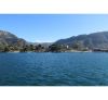
Lake Atitlan
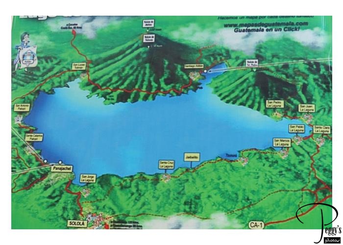
A map of Lake Atitlan, showing its three volcanoes, Atitlan, Toliman, and San Pedro, and the towns on the lake. We took a boat cruise on the lake. There are many towns on the lake with mostly Mayan residents.
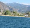
Lake Atitlan
Lake Atitlan
The area around Lake Atitlan was made a national park in 1955. The lake itself is 50.2 square miles. The lake fills a volcanic caldera.
Lake Atitlan
Lake Atitlan
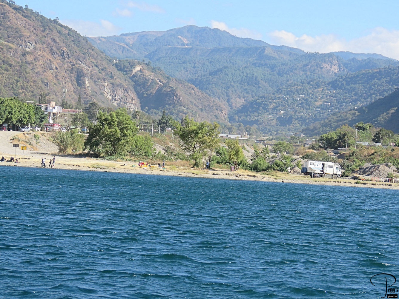
A long stretch of beach along the lake.
Lake Atitlan
Lake Atitlan

What was surprising here were the large number of large well–built and mainly modern houses on the lake. It didn’t look like the Guatemala that we had gotten to know.
Lake Atitlan
San Pedro Volcano
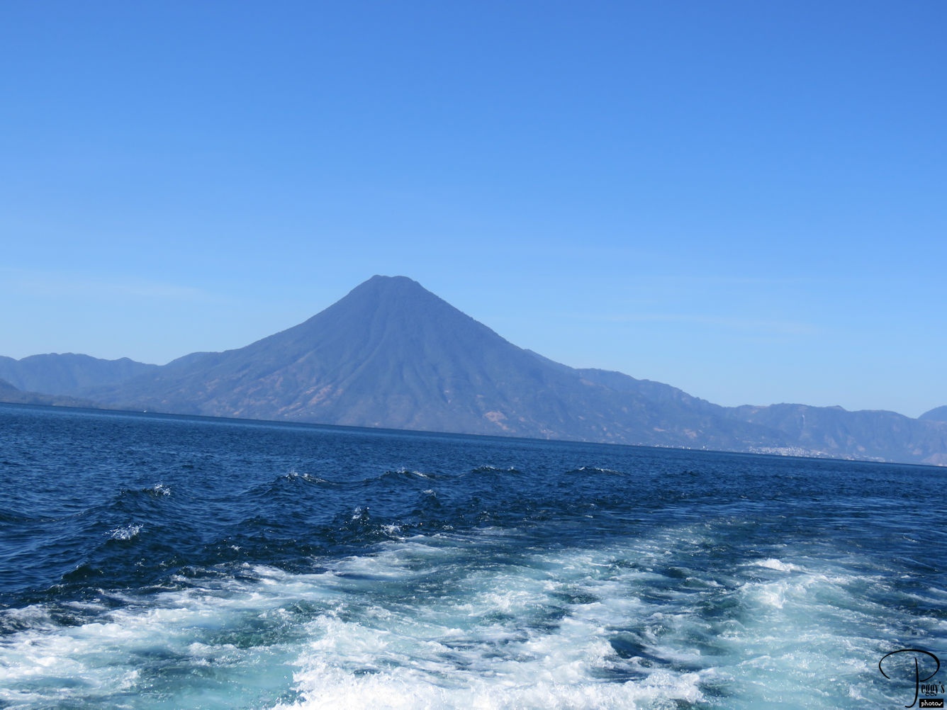
The San Pedro volcano, which is believed to be inactive as it hasn’t erupted during historical times.
San Pedro Volcano
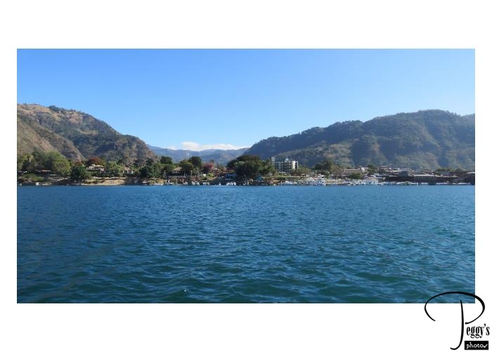
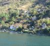
Lake Atitlan Town
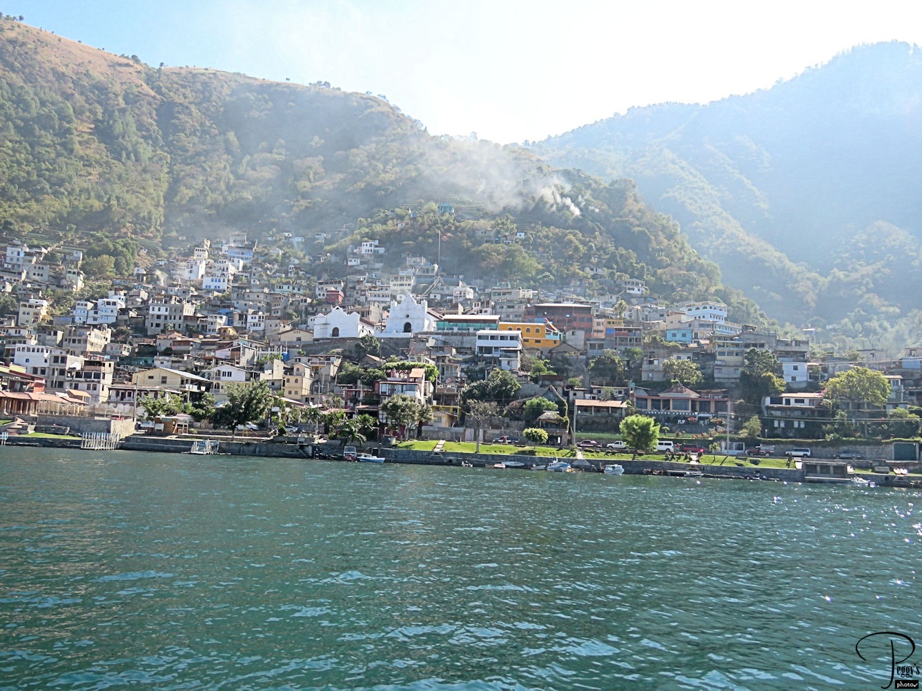
One of the towns along the lake.
Lake Atitlan Town
Three Volcanoes
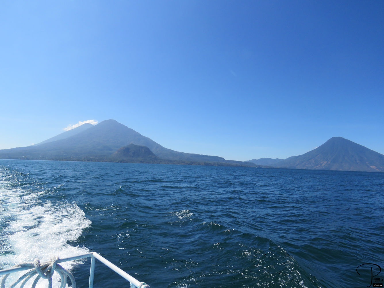
You can see all three of Lake Atitlan’s volcanoes in this photo. On the left in front of the Atitlan volcano is the Toliman volcano. Behind it, emitting smoke, is the active Atitlan volcano. To the right, is the San Pedro volcano.
I have put my photos of our cruise on Lake Atitlan on a slideshow. Go to
http://www.peggysphotos.com/lake–atitlan/
(Slide Shows, Central America, Guatemala, “Lake Atitlan”)>
Three Volcanoes
Leaving Lake Atitlan
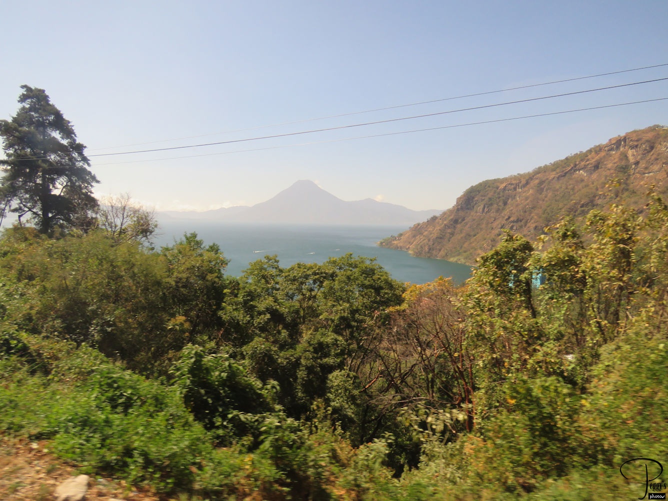
After our boat cruise, we left Lake Atitlan to drive back to Guatemala City. On the mountain road, we still have views of Lake Atitlan.
Leaving Lake Atitlan
Lake Atitlan Town
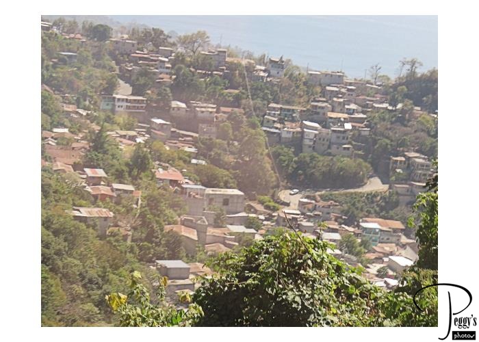
Also from the mountain road, we could look down on towns on the hills above Lake Atitlan.
Lake Atitlan Town
Guatemalan Cemetery
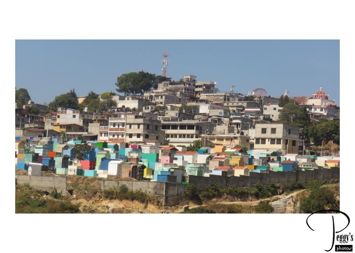
We passed this colorful cemetery which I think is the one in Chichicastenango.
Guatemalan Cemetery
Guatemalan Farmland
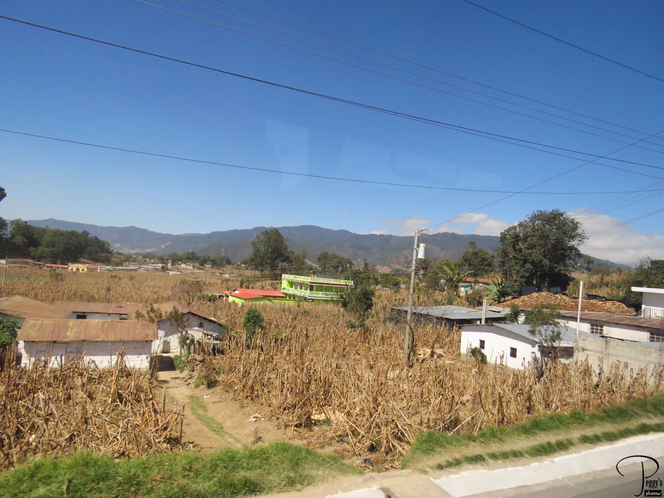
On our way back to Guatemala City, we passed many farms, these with dry corn stalks.
Guatemalan Farmland
Guatemalan Countryside
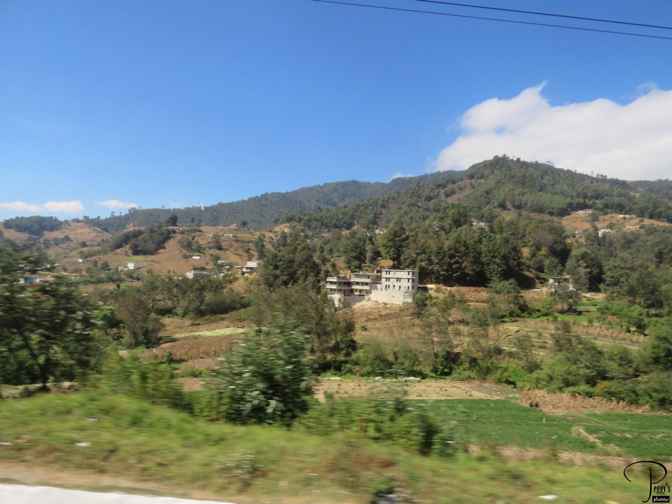
We also passed much countryside.
Guatemalan Countryside
Guatemala City
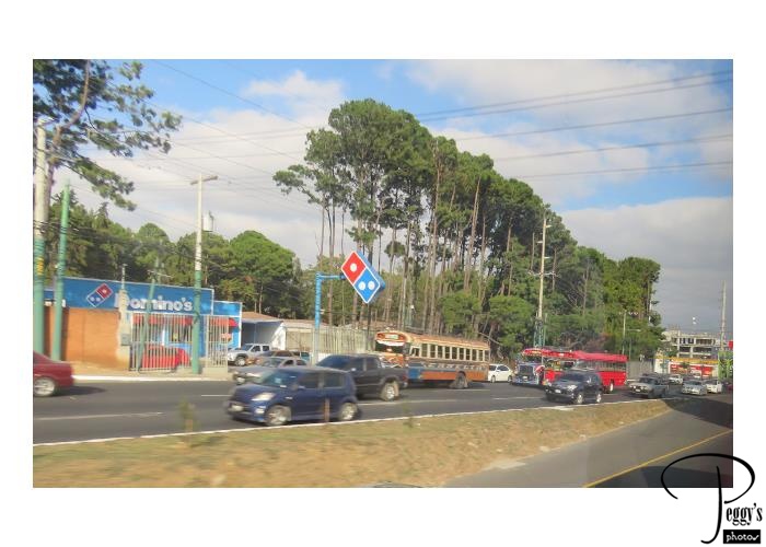
You can tell that we reached the big city by the Domino’s pizza signs.
I have put my photos of our drive from Lake Atitlan to Guatemala City on a slideshow. Go to
http://www.peggysphotos.com/lake–atitlan–to–guatemala–city/
(Slideshows, Central America, Guatemala, “Lake Atitlan to Guatemala City”).
Guatemala City
Torre del Reformador
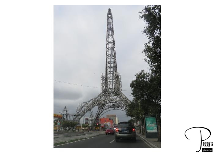
After we arrived at our hotel in Guatemala City, I took a taxi to the Iglesia Yurrita. We had passed by it on our first tour day in Guatemala and I wanted to take better photos of it than I got on the pass by. My taxi drove under the Torre del Reformador, Guatemala City’s Eiffel Tower.
Torre del Reformador
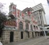
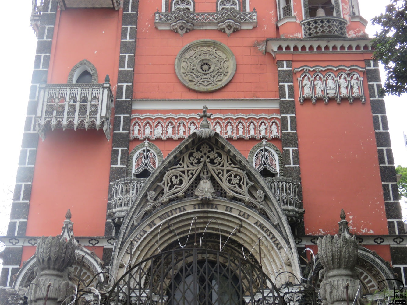
Iglesia Yurrita
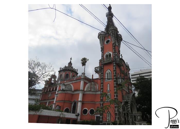
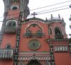
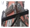
This unusual Catholic church was built by the Yurrita family in 1929 and is called the Iglesia Yurrita by everyone. It is also known as La Capilla de Nuestra Senora de las Angustias (the Chapel of Our Lady of Anguish). View from the side.
Iglesia Yurrita
Iglesia Yurrita
View from the side.
Iglesia Yurrita
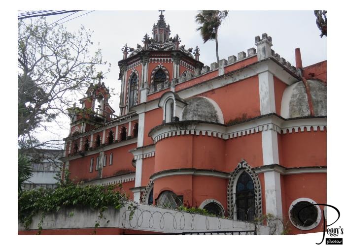
Iglesia Yurrita
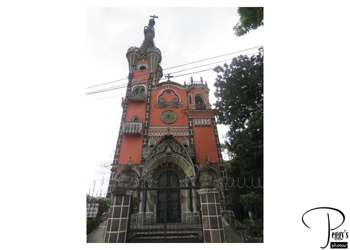
View from the front.
Iglesia Yurrita
Iglesia Yurrita
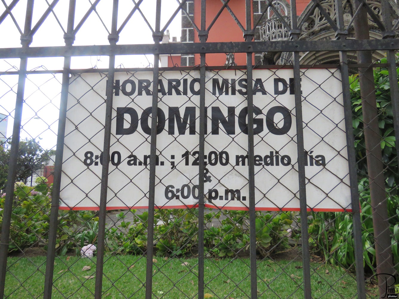
You can attend mass at the church on Sundays and also see the inside of the church, which is also unusual. You can find photos of its inside and some very good photos of the church, most without the fencing around it, by googling “Iglesia Yurrita photos.”

Iglesia Yurrita
Iglesia Yurrita
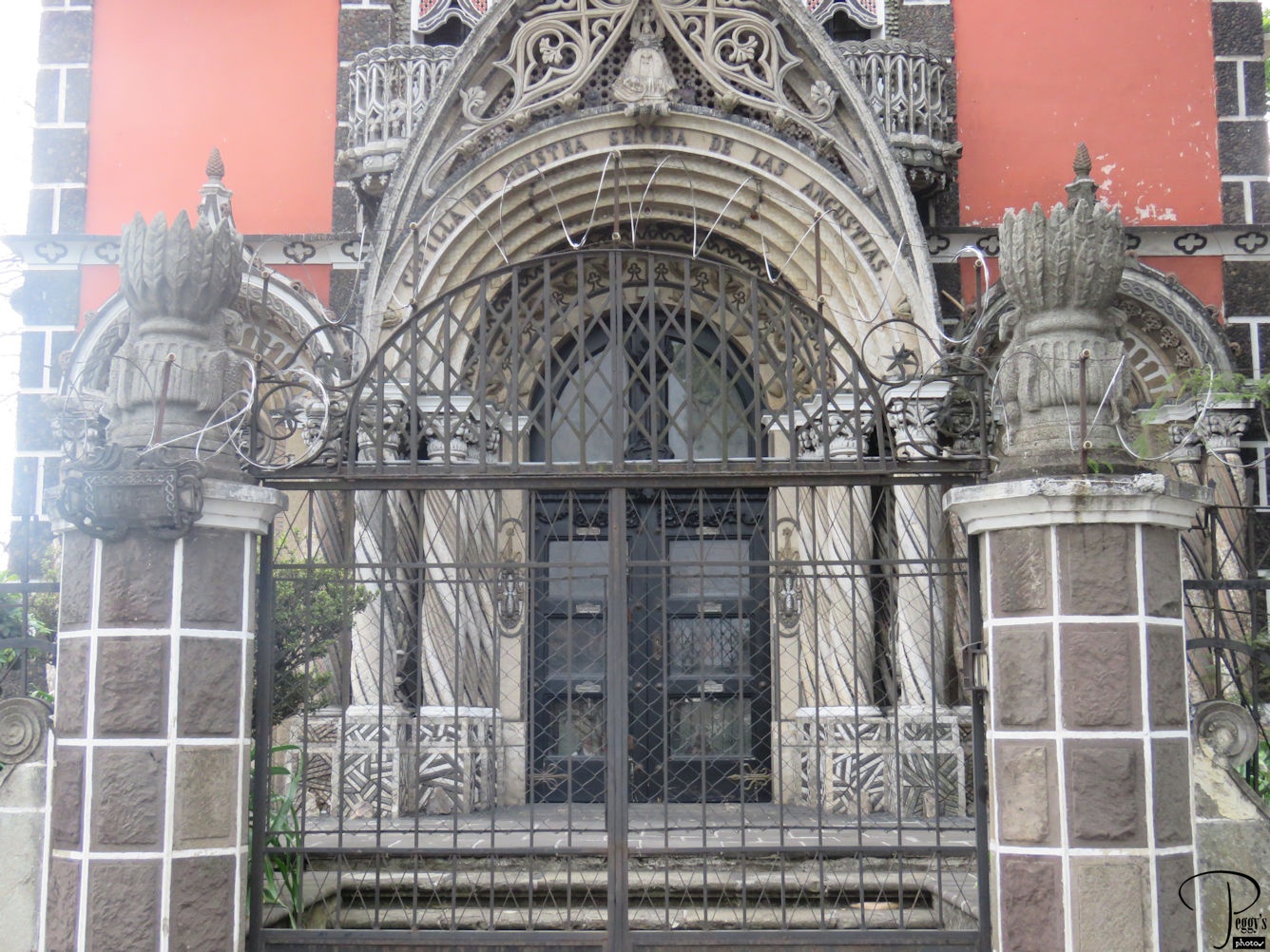
Entrance to the church.
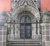
Iglesia Yurrita
Iglesia Yurrita
Above the entrance.
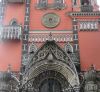
Iglesia Yurrita
Iglesia Yurrita
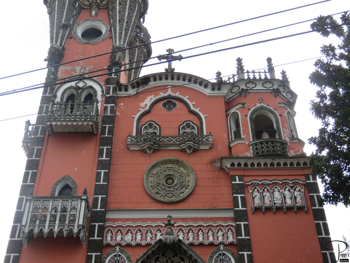
Near the top.
Iglesia Yurrita
Iglesia Yurrita
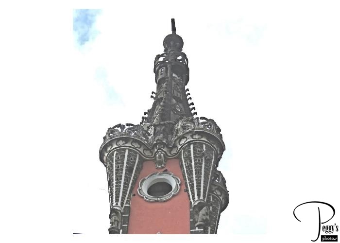
The top.
Iglesia Yurrita
Iglesia Yurrita

Its balconies.
Iglesia Yurrita
Casa Yurrita
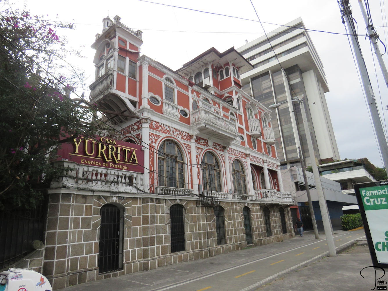
Next door to the Iglesia Yurrita is the Casa Yurrita where events can be held.
We had our farewell dinner tonight at our hotel. Time to say goodbye to the new friends we made on our tour. However, a number of us were on the same 5 a.m. shuttle to the airport the next day. I flew from Guatemala City to Panama City on Copa Airlines, a 2.5–hour flight. I was met at the Panama City airport and my hotel room was ready for me. I spent most of the day taking a very long nap before starting a new tour.